
Make a donation
Saskatchewan topographic map
Click on the map to display elevation.
Make a donation
About this map
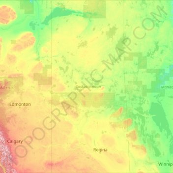
Name: Saskatchewan topographic map, elevation, terrain.
Location: Saskatchewan, Canada (48.99881 -110.00637 60.00003 -101.36191)
Average elevation: 511 m
Minimum elevation: 175 m
Maximum elevation: 3,227 m
Make a donation
Other topographic maps
Click on a map to view its topography, its elevation and its terrain.
Lund
Canada > British Columbia > qathet Regional District > Area A (Malaspina/Toba)
Average elevation: 57 m
Starkey Hill Conservation Area
Canada > Ontario > Wellington County > Puslinch > Arkell
Average elevation: 348 m
Little Current
Canada > Ontario > Manitoulin District > Northeastern Manitoulin and the Islands
Average elevation: 193 m
Make a donation
Make a donation
Make a donation
Miocene
Canada > British Columbia > Cariboo Regional District > Area F (Horsefly/Likely/150 Mile House)
Average elevation: 1,009 m
Make a donation
Waterton Park
Canada > Alberta > Division No. 3
It is located at the southwestern terminus of Highway 5, approximately 54 kilometres (34 mi) west of the Town of Cardston and 55 kilometres (34 mi) south of the Town of Pincher Creek. This hamlet is north of Glacier National Park in Montana. It has an elevation of 1,280 metres (4,200 ft).
Average elevation: 1,456 m
Make a donation
Make a donation
Eagle Creek
Canada > British Columbia > Cariboo Regional District > Area H (Canim Lake/Forest Grove)
Average elevation: 824 m
Mount Howard-Stowe
Canada > British Columbia > Cariboo Regional District > Area J (West Chilcotin)
Average elevation: 2,125 m