
283 topographic map
Interactive map
Click on the map to display elevation.
About this map
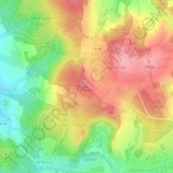
Name: 283 topographic map, elevation, terrain.
Average elevation: 239 m
Minimum elevation: 173 m
Maximum elevation: 298 m
Other topographic maps
Click on a map to view its topography, its elevation and its terrain.
Horn-Bad Meinberg
Allemagne > Rhénanie-du-Nord-Westphalie > Horn-Bad Meinberg
Horn-Bad Meinberg, Kreis Lippe, Regierungsbezirk Detmold, Rhénanie-du-Nord-Westphalie, 32805, Allemagne
Average elevation: 239 m