
Make a donation
Dover topographic map
Click on the map to display elevation.
Make a donation
About this map
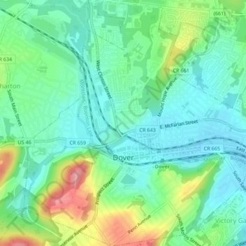
Name: Dover topographic map, elevation, terrain.
Location: Dover, Morris County, New Jersey, 07801, United States (40.87262 -74.57896 40.90411 -74.53811)
Average elevation: 205 m
Minimum elevation: 169 m
Maximum elevation: 289 m
Make a donation
Other topographic maps
Click on a map to view its topography, its elevation and its terrain.
Shongum Lake Dam
United States > New Jersey > Morris County > Randolph Township
Average elevation: 255 m
Make a donation
Lake Cherokee
United States > New Jersey > Morris County > Randolph Township > Calais Crossroads
Average elevation: 295 m
Woodland Lake
United States > New Jersey > Morris County > Pequannock Township
Average elevation: 61 m
Make a donation
Springtown
United States > New Jersey > Morris County > Washington Township > Long Valley
Average elevation: 270 m
Make a donation
Prospect Point
United States > New Jersey > Morris County > Jefferson Township
Average elevation: 304 m
Make a donation
Farny State Park
United States > New Jersey > Morris County > Rockaway Township
Average elevation: 290 m
Lake Hiawatha
United States > New Jersey > Morris County > Parsippany-Troy Hills
Average elevation: 77 m
Boonton Township
United States > New Jersey > Morris County > Boonton Township
Average elevation: 192 m
Make a donation
Make a donation
Oak Ridge Dam
United States > New Jersey > Morris County > Jefferson Township
Average elevation: 266 m
Make a donation
Make a donation
Florham Park
United States > New Jersey > Morris County > Florham Park > Florham Park
Average elevation: 70 m
Tierneys Corner
United States > New Jersey > Morris County > Jefferson Township > Tierneys Corner
Average elevation: 301 m
Coleman Hollow
United States > New Jersey > Morris County > Randolph Township > Coleman Hollow
Average elevation: 263 m
Make a donation
Rockaway Township
United States > New Jersey > Morris County > Rockaway Township
Average elevation: 219 m
Make a donation
Roxbury Township
United States > New Jersey > Morris County > Roxbury Township
Average elevation: 264 m