
Thank you for supporting this site ❤️
Make a donation
Make a donation
Magnolia topographic map
Click on the map to display elevation.
Thank you for supporting this site ❤️
Make a donation
Make a donation
About this map
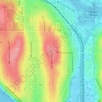
Name: Magnolia topographic map, elevation, terrain.
Location: Magnolia, Seattle, King County, Washington, 98199, USA (47.64889 -122.39317 47.64899 -122.39307)
Average elevation: 52 m
Minimum elevation: 0 m
Maximum elevation: 117 m
Thank you for supporting this site ❤️
Make a donation
Make a donation
Other topographic maps
Click on a map to view its topography, its elevation and its terrain.