
Thank you for supporting this site ❤️
Make a donation
Make a donation
Lac Lovering topographic map
Click on the map to display elevation.
Thank you for supporting this site ❤️
Make a donation
Make a donation
About this map
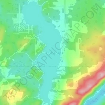
Name: Lac Lovering topographic map, elevation, terrain.
Location: Lac Lovering, Magog, Memphrémagog, Estrie, Québec, Canada (45.14180 -72.17284 45.19418 -72.14448)
Average elevation: 280 m
Minimum elevation: 224 m
Maximum elevation: 420 m
Thank you for supporting this site ❤️
Make a donation
Make a donation
Other topographic maps
Click on a map to view its topography, its elevation and its terrain.