Geolocate

Johor topographic map

Click on the map to display elevation.

About this map

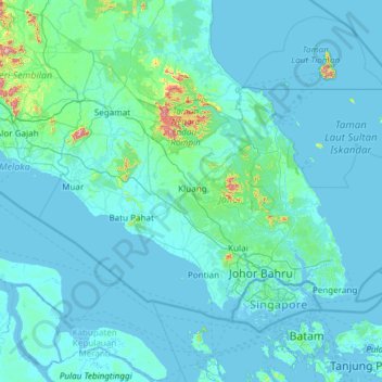
Name: Johor topographic map, elevation, terrain.

Location: Johor, Malaysia (1.19567 102.34749 2.83464 104.75120)

Average elevation: 31 m

Minimum elevation: -1 m

Maximum elevation: 1,069 m

Other topographic maps

Click on a map to view its topography, its elevation and its terrain.

Pahang

Malaysia > Pahang

The highest peak, Mount Tahan, reaches 2,187 m (7,175 ft) in elevation, which is also the highest point in the Peninsular Malaysia. The climate is temperate enough to have distinct temperature variations year round, and much of the highlands are covered with tropical rainforest. Pahang is home to Malaysia's…

Average elevation: 90 m

Penang Island

Malaysia > Penang Island

Penang Island is irregularly shaped, with a hilly and mostly forested interior; its coastal plains are narrow, the most extensive of which is at the northeastern cape. With a height of 833 m (2,733 ft), Penang Hill, at the centre of the island, is the tallest point within Penang. From a small settlement at the…

Average elevation: 117 m

Kuala Terengganu

Malaysia > Terengganu > Kuala Terengganu

As a part of Terengganu, Kuala Terengganu has a tropical rainforest climate under the Köppen climate classification (Af) with constant temperature and high humidity. The amount of rainfall varies according to the monsoon season. It is generally fairly hot and humid all year round, averaging from 28 °C to 30…

Average elevation: 9 m

Kuala Lumpur

Malaysia > Kuala Lumpur

Located in the centre of Selangor state, Kuala Lumpur was a territory of Selangor State Government. In 1974, Kuala Lumpur was split off from Selangor to form the first Federal Territory governed directly by the Malaysian federal government. Its location in the most developed state on the west coast of…

Average elevation: 127 m

Taiping

Malaysia > Perak

Average elevation: 193 m

Puchong

Malaysia > Selangor > Subang Jaya City Council

Average elevation: 38 m

Kuching

Malaysia > Sarawak > Kuching

Average elevation: 17 m

Johor Bahru

Malaysia > Johor

Average elevation: 23 m

Miri

Malaysia > Sarawak > Miri

Average elevation: 9 m

Seremban

Malaysia > Negeri Sembilan

Average elevation: 168 m

Tubau

Malaysia > Sarawak > Sebauh

Average elevation: 16 m

Bintulu

Malaysia > Sarawak > Bintulu

Average elevation: 18 m

Sarawak River

Malaysia > Sarawak > Kuching

Average elevation: 6 m

Kampung Bukit Jana

Malaysia > Perak > Kamunting

Average elevation: 169 m

Batu Kawan

Malaysia > Penang

Average elevation: 5 m

Ipoh

Malaysia > Perak > Majlis Bandaraya Ipoh

Average elevation: 205 m

Cyberjaya

Malaysia > Selangor > Cyberjaya

Average elevation: 24 m

Sibu

Malaysia > Sarawak > Sibu

Sibu is located near the Rajang delta at the confluence of Rajang and Igan rivers. Peat swamp forests and alluvial plains are particularly prevalent in the Sibu Division. Sibu is located on a deep peat soil, which has caused problems in infrastructure development because buildings and roads slowly sink into…

Average elevation: 10 m

Puncak Alam

Malaysia > Selangor > Puncak Alam

Average elevation: 30 m

Kangar

Malaysia > Perlis

Average elevation: 28 m

Cameron Highlands

Malaysia > Pahang

Surveyed by the government geologist and explorer William Cameron in 1885, the outpost consists of three mukims (subdistricts), namely Ringlet, Tanah Rata and Ulu Telom. Its eight settlements are Ringlet, Tanah Rata (the administrative centre), Brinchang, the Bertam Valley, Kea Farm, Tringkap, Kampung Kuala…

Average elevation: 1,400 m

Kapit

Malaysia > Sarawak > Kapit

Average elevation: 175 m

Klang

Malaysia > Selangor > Klang

Average elevation: 13 m

Kota Kinabalu

Malaysia > Sabah

Average elevation: 86 m

Semenyih

Malaysia > Selangor > Kajang Municipal Council

Average elevation: 62 m

Port Dickson

Malaysia > Negeri Sembilan

Average elevation: 14 m

Subang Jaya

Malaysia > Selangor > Subang Jaya

Average elevation: 35 m

Titiwangsa Lake Garden

Malaysia > Kuala Lumpur

Average elevation: 42 m

Mount Kinabalu

Malaysia > Sabah > Ranau

Mount Kinabalu (Malay: Gunung Kinabalu, Dusun: Gayo Ngaran or Nulu Nabalu) is the highest mountain in Borneo and Malaysia. With an elevation of 13,435 feet (4,095 m), it is third-highest peak of an island on Earth, and 20th most prominent mountain in the world by topographic prominence. The mountain is located…

Average elevation: 3,567 m

Ringlet

Malaysia > Pahang

Situated at an altitude of 1,135 metres above sea level (3,723 ft), Ringlet is a hub of Malaysia's vegetable farming and international flower farming sector. The town contains some other small villages such as Bertam Valley, Boh and Habu Height.

Average elevation: 1,183 m

Siburan

Malaysia > Sarawak > Kuching

Average elevation: 27 m

Jementah

Malaysia > Johor

Average elevation: 54 m

Jenjarom

Malaysia > Selangor

Average elevation: 4 m

Kampung Krubong

Malaysia > Malacca

Average elevation: 13 m

Betong Hill

Malaysia > Pahang

Average elevation: 90 m

Kampung Lembah Hijau

Malaysia > Sarawak > Miri

Average elevation: 19 m

RH. Sulong

Malaysia > Sarawak > Bintulu

Average elevation: 35 m

Port Dickson

Malaysia > Negeri Sembilan

Average elevation: 14 m

Mengalum Island

Malaysia > Sabah

Average elevation: 5 m

Balik Pulau

Malaysia > Penang > George Town

Average elevation: 136 m

Tapah

Malaysia > Perak

Average elevation: 66 m

Kundasang

Malaysia > Sabah > Ranau

Average elevation: 1,291 m

Kampung Bukit Kecil

Malaysia > Malacca > Malacca City

Average elevation: 9 m

Kampung Jerantut Peri

Malaysia > Pahang

Average elevation: 61 m

Kampung Dendang

Malaysia > Terengganu > Dungun

Average elevation: 18 m

Pengkalan Kempas

Malaysia > Negeri Sembilan

Average elevation: 13 m

Kampar

Malaysia > Perak

Average elevation: 240 m

Kampung Suluk

Malaysia > Penang > George Town

Average elevation: 61 m

Kampung Kuantan

Malaysia > Selangor > Kuala Selangor

Average elevation: 4 m

Sungai Sum Sum

Malaysia > Pahang > Bukit Tinggi

Average elevation: 431 m

Pantai Remis

Malaysia > Perak

Average elevation: 3 m

Kampung Pengkalan Rambutan

Malaysia > Kelantan

Average elevation: 13 m

Temerloh

Malaysia > Pahang

Average elevation: 48 m

Alor Setar

Malaysia > Kedah

Average elevation: 9 m

Seri Iskandar

Malaysia > Perak

Seri Iskandar (Jawi: سري إسكندر, Chinese: 斯里依斯干达) is a major town within the Perak Tengah District in the state of Perak, Malaysia. It is situated about 40 kilometers southwest of the city of Ipoh, the state capital. The town is at an average elevation of 29 meters above the sea level. The…

Average elevation: 29 m

Batu Pahat

Malaysia > Johor

Average elevation: 10 m

Kuantan

Malaysia > Pahang

Average elevation: 14 m

Sungai Petani

Malaysia > Kedah

Average elevation: 45 m

Genting Highlands

Malaysia > Pahang

Genting Highlands is a hill station and a city located on the peak of Mount Ulu Kali in the Titiwangsa Mountains, central Peninsular Malaysia, at 1800 metres elevation. It is the second seat of Bentong District after Bentong. Located in the state of Pahang. It was established in 1965 by the late Malaysian…

Average elevation: 1,141 m

Gua Musang

Malaysia > Kelantan

Average elevation: 144 m

Gerik

Malaysia > Perak > Gerik

Average elevation: 163 m

Kampung Seri Perkasa

Malaysia > Perak

Average elevation: 4 m

Kampung Marhum

Malaysia > Pahang

Average elevation: 4 m

Johor Bahru

Malaysia > Johor

Average elevation: 23 m

Bukit Simbang

Malaysia > Johor

Average elevation: 116 m

Bukit Kerinting

Malaysia > Johor > Kampung Panca Jaya

Average elevation: 64 m

Kampung Rapak

Malaysia > Sabah > Ranau > Togudon Baru

Average elevation: 546 m

Kampung Bendang Raja

Malaysia > Kedah

Average elevation: 18 m

Kampung Bakau Tua

Malaysia > Penang

Average elevation: 3 m

Sungai Bekok

Malaysia > Johor

Average elevation: 77 m

Kuala Tahan

Malaysia > Pahang

Average elevation: 131 m

RPR Matang Sungai Tengah 2

Malaysia > Sarawak > Kuching

Average elevation: 18 m

Kampung Behrang Ulu

Malaysia > Perak

Average elevation: 55 m

Kampar

Malaysia > Perak

Average elevation: 240 m

Kampung Larut Ulu

Malaysia > Perak > Changkat Jering

Average elevation: 49 m

Sri Gading

Malaysia > Johor

Average elevation: 8 m

Kampung Pengkalan Pegoh

Malaysia > Perak > Ipoh

Average elevation: 36 m

Padang Sira

Malaysia > Kedah

Average elevation: 10 m

FELDA Pemanis

Malaysia > Johor > Segamat

Average elevation: 50 m

Sirian

Malaysia > Kelantan

Average elevation: 87 m

Kota Perdana

Malaysia > Pahang

Average elevation: 42 m

Kuala Kangsar

Malaysia > Perak

Average elevation: 283 m

Puchong

Malaysia > Selangor > Subang Jaya City Council

Average elevation: 38 m

Kampung Paya Buluh

Malaysia > Malacca

Average elevation: 15 m

Kampung Naga

Malaysia > Kedah

Average elevation: 6 m

Kuala Krau

Malaysia > Pahang

Average elevation: 55 m

Sungai Penerok

Malaysia > Johor > Pekan Penerok

Average elevation: 5 m

AA Tin Village

Malaysia > Perak > Sungkai

Average elevation: 46 m

Tanjung Tualang

Malaysia > Perak

Average elevation: 29 m

Kampung Soh

Malaysia > Sarawak > Serian

Average elevation: 7 m

Gunung Yong Belar

Malaysia > Kelantan

Average elevation: 1,713 m