
Thank you for supporting this site ❤️
Make a donation
Make a donation
Kuma River topographic map
Click on the map to display elevation.
Thank you for supporting this site ❤️
Make a donation
Make a donation
About this map
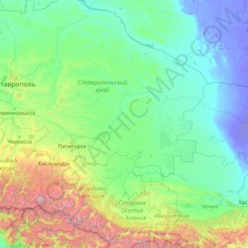
Name: Kuma River topographic map, elevation, terrain.
Location: Kuma River, North Caucasian Federal District, Russia (43.80887 42.14306 44.99790 46.99409)
Average elevation: 548 m
Minimum elevation: -23 m
Maximum elevation: 5,603 m
Thank you for supporting this site ❤️
Make a donation
Make a donation
Other topographic maps
Click on a map to view its topography, its elevation and its terrain.
Khatanga
Russia > Krasnoyarsk Krai > Taymyrsky Dolgano-Nenetsky District
Khatanga (Russian: Ха́танга) is a rural locality (a selo) in Taymyrsky Dolgano-Nenetsky District of Krasnoyarsk Krai, Russia, located on the Khatanga River on the Taymyr Peninsula. It is one of the northernmost inhabited localities in Russia. Its elevation is 30 metres (98 ft) above sea level. As of…
Average elevation: 11 m
Thank you for supporting this site ❤️
Make a donation
Make a donation
Thank you for supporting this site ❤️
Make a donation
Make a donation
Thank you for supporting this site ❤️
Make a donation
Make a donation
Thank you for supporting this site ❤️
Make a donation
Make a donation