
Thank you for supporting this site ❤️
Make a donation
Make a donation
Evansville topographic map
Click on the map to display elevation.
Thank you for supporting this site ❤️
Make a donation
Make a donation
About this map
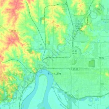
Name: Evansville topographic map, elevation, terrain.
Location: Evansville, Vanderburgh County, Indiana, United States (37.93559 -87.63755 38.05689 -87.44987)
Average elevation: 122 m
Minimum elevation: 105 m
Maximum elevation: 179 m
Thank you for supporting this site ❤️
Make a donation
Make a donation
Other topographic maps
Click on a map to view its topography, its elevation and its terrain.
Country Club Meadows
United States > Indiana > Vanderburgh County > Evansville
Average elevation: 126 m
Thank you for supporting this site ❤️
Make a donation
Make a donation