Saint-Marcel-d'en-Bas topographic map
Interactive map
Click on the map to display elevation.
About this map
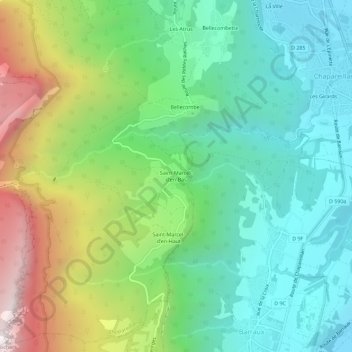
Name: Saint-Marcel-d'en-Bas topographic map, elevation, terrain.
Average elevation: 753 m
Minimum elevation: 249 m
Maximum elevation: 1,827 m

Click on the map to display elevation.
Name: Saint-Marcel-d'en-Bas topographic map, elevation, terrain.
Average elevation: 753 m
Minimum elevation: 249 m
Maximum elevation: 1,827 m