
Doudrac topographic map
Interactive map
Click on the map to display elevation.
About this map
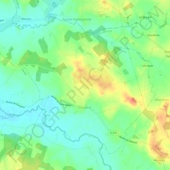
Name: Doudrac topographic map, elevation, terrain.
Average elevation: 88 m
Minimum elevation: 69 m
Maximum elevation: 117 m
Other topographic maps
Click on a map to view its topography, its elevation and its terrain.
Tournon-d'Agenais
France > Nouvelle-Aquitaine > Lot-et-Garonne
Tournon-d'Agenais, Villeneuve-sur-Lot, Lot-et-Garonne, Nouvelle-Aquitaine, France métropolitaine, 47370, France
Average elevation: 184 m
Moustier
France > Nouvelle-Aquitaine > Lot-et-Garonne
Moustier, Marmande, Lot-et-Garonne, Nouvelle-Aquitaine, France métropolitaine, 47800, France
Average elevation: 71 m
Tonneins
France > Nouvelle-Aquitaine > Lot-et-Garonne > Tonneins
Tonneins, Marmande, Lot-et-Garonne, Nouvelle-Aquitaine, France métropolitaine, 47400, France
Average elevation: 49 m
Agen
France > Nouvelle-Aquitaine > Lot-et-Garonne > Agen
Agen, Lot-et-Garonne, Nouvelle-Aquitaine, France métropolitaine, 47000, France
Average elevation: 67 m