
Schachendorf topographic map
Interactive map
Click on the map to display elevation.
About this map
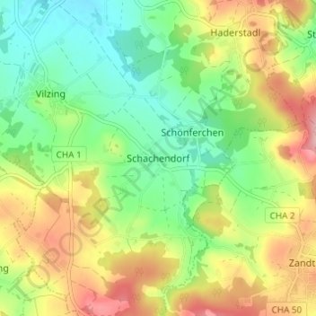
Name: Schachendorf topographic map, elevation, terrain.
Location: Schachendorf, Cham, Landkreis Cham, Bayern, 93499, Deutschland (49.14884 12.67791 49.18884 12.71791)
Average elevation: 441 m
Minimum elevation: 377 m
Maximum elevation: 533 m
Other topographic maps
Click on a map to view its topography, its elevation and its terrain.
Sauberg
Deutschland > Bayern > Landkreis Cham > Cham
Sauberg, Cham, Landkreis Cham, Bayern, 93483, Deutschland
Average elevation: 400 m