
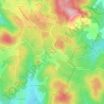
Le Monteil topographic map
Interactive map
Click on the map to display elevation.
About this map
Name: Le Monteil topographic map, elevation, terrain.
Average elevation: 727 m
Minimum elevation: 606 m
Maximum elevation: 866 m
Other topographic maps
Click on a map to view its topography, its elevation and its terrain.
Les Chaussades
France > Nouvelle-Aquitaine > Corrèze > Saint-Yrieix-le-Déjalat
Les Chaussades, Saint-Yrieix-le-Déjalat, Ussel, Corrèze, Nouvelle-Aquitaine, France métropolitaine, 19300, France
Average elevation: 699 m
Commerly
France > Nouvelle-Aquitaine > Corrèze > Saint-Yrieix-le-Déjalat
Commerly, Saint-Yrieix-le-Déjalat, Ussel, Corrèze, Nouvelle-Aquitaine, France métropolitaine, 19300, France
Average elevation: 757 m
Laborde
France > Nouvelle-Aquitaine > Corrèze > Saint-Yrieix-le-Déjalat
Laborde, Saint-Yrieix-le-Déjalat, Ussel, Corrèze, Nouvelle-Aquitaine, France métropolitaine, 19300, France
Average elevation: 686 m