
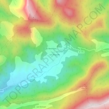
Les Thibauds topographic map
Interactive map
Click on the map to display elevation.
About this map
Name: Les Thibauds topographic map, elevation, terrain.
Average elevation: 1,057 m
Minimum elevation: 703 m
Maximum elevation: 1,527 m
Other topographic maps
Click on a map to view its topography, its elevation and its terrain.
Les Terraillons
France > Auvergne-Rhône-Alpes > Drôme > Miscon
Les Terraillons, Miscon, Die, Drôme, Auvergne-Rhône-Alpes, France métropolitaine, 26310, France
Average elevation: 1,050 m
Les Lamberts
France > Auvergne-Rhône-Alpes > Drôme > Miscon
Les Lamberts, Miscon, Die, Drôme, Auvergne-Rhône-Alpes, France métropolitaine, 26310, France
Average elevation: 1,061 m