
Delaware County topographic map
Interactive map
Click on the map to display elevation.
About this map
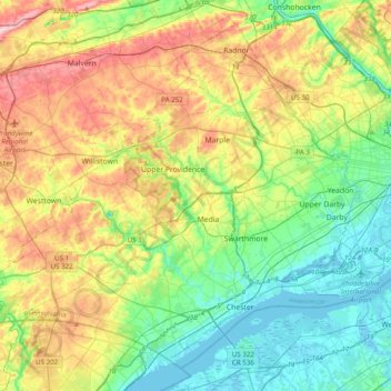
Name: Delaware County topographic map, elevation, terrain.
Location: Delaware County, Pennsylvania, United States of America (39.80231 -75.60158 40.06630 -75.21142)
Average elevation: 76 m
Minimum elevation: -4 m
Maximum elevation: 215 m
Other topographic maps
Click on a map to view its topography, its elevation and its terrain.
Erie County
United States of America > Pennsylvania
Erie County, Pennsylvania, United States of America
Average elevation: 248 m
Lehigh County
United States of America > Pennsylvania
Lehigh County, Pennsylvania, United States of America
Average elevation: 186 m
Crawford County
United States of America > Pennsylvania
Crawford County, Pennsylvania, United States of America
Average elevation: 382 m
Beaver County
United States of America > Pennsylvania
Beaver County, Pennsylvania, United States of America
Average elevation: 325 m
Bedford County
United States of America > Pennsylvania
Bedford County, Pennsylvania, United States of America
Average elevation: 491 m