
Make a donation
Somerville topographic map
Click on the map to display elevation.
Make a donation
Somerville
Somerville's commercial property is not concentrated in a recognized downtown central business district but instead is spread over many different nodes or corridors of business activity. The difference in character ranges from the vibrant nightlife, live music and theaters of Davis Square to the large scale retail and highway access of Assembly Square. This spatial allocation is directly related to the early influence of rail and streetcar systems which caused economic activity to occur at stops. The other key factor in the creation of commercial squares is the area's topography. The numerous hills making up Somerville's landscape determined where road networks would allow neighborhood commercial development.
Make a donation
About this map
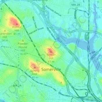
Name: Somerville topographic map, elevation, terrain.
Location: Somerville, Middlesex County, Massachusetts, United States (42.37253 -71.13464 42.41816 -71.07269)
Average elevation: 11 m
Minimum elevation: -5 m
Maximum elevation: 47 m
Make a donation
Other topographic maps
Click on a map to view its topography, its elevation and its terrain.
Make a donation
North Chelmsford
United States > Massachusetts > Middlesex County > Chelmsford
Average elevation: 41 m
Make a donation
Make a donation
Medford Hillside
United States > Massachusetts > Middlesex County > Medford > West Medford
Average elevation: 13 m
Make a donation
Hobbs Road
United States > Massachusetts > Middlesex County > Wayland > Cochituate
Average elevation: 66 m
Make a donation
Make a donation
Make a donation
Make a donation
North Chelmsford
United States > Massachusetts > Middlesex County > Chelmsford
Average elevation: 41 m
Make a donation
Arlington Heights
United States > Massachusetts > Middlesex County > Arlington
Average elevation: 58 m
Make a donation
Make a donation
Framingham Center
United States > Massachusetts > Middlesex County > Framingham
Average elevation: 58 m
Make a donation
Cambridge
United States > Massachusetts > Middlesex County > Cambridge
Cambridge obtains water from Hobbs Brook (in Lincoln and Waltham) and Stony Brook (Waltham and Weston), as well as an emergency connection to the Massachusetts Water Resources Authority. The city owns over 1,200 acres (486 ha) of land in other towns that includes these reservoirs and portions of their…
Average elevation: 31 m
Make a donation
Glendale
United States > Massachusetts > Middlesex County > Everett > Glendale
Average elevation: 14 m
Make a donation
East Acton
United States > Massachusetts > Middlesex County > Acton > East Acton
Average elevation: 53 m
Weston Station
United States > Massachusetts > Middlesex County > Weston > Weston Station
Average elevation: 55 m
Make a donation