
Schaffhausen topographic map
Interactive map
Click on the map to display elevation.
About this map
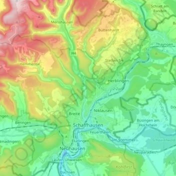
Name: Schaffhausen topographic map, elevation, terrain.
Location: Schaffhausen, Zwitserland (47.68530 8.54100 47.75308 8.70594)
Average elevation: 539 m
Minimum elevation: 355 m
Maximum elevation: 919 m
Other topographic maps
Click on a map to view its topography, its elevation and its terrain.
Neuhausen
Zwitserland > Schaffhausen > Neuhausen
Neuhausen, Schaffhausen, 8212, Zwitserland
Average elevation: 471 m
Thayngen
Zwitserland > Schaffhausen > Thayngen
Thayngen, Schaffhausen, Zwitserland
Average elevation: 524 m
Ramsen
Zwitserland > Schaffhausen > Ramsen
Ramsen, Schaffhausen, 8262, Zwitserland
Average elevation: 453 m