
Les Infruits topographic map
Interactive map
Click on the map to display elevation.
About this map
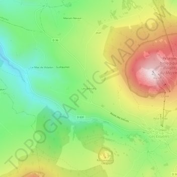
Name: Les Infruits topographic map, elevation, terrain.
Average elevation: 1,347 m
Minimum elevation: 1,097 m
Maximum elevation: 1,686 m
Other topographic maps
Click on a map to view its topography, its elevation and its terrain.
La Vacheresse
France > Auvergne-Rhône-Alpes > Haute-Loire > Les Estables
La Vacheresse, Les Estables, Le Puy-en-Velay, Haute-Loire, Auvergne-Rhône-Alpes, France métropolitaine, 43150, France
Average elevation: 1,260 m