
Make a donation
Mollens (VS) topographic map
Click on the map to display elevation.
Make a donation
Mollens (VS)
The former municipality is located in the Sierre district, on the right bank of the Rhone river. The municipality stretches from an elevation of 900 to 3,177 m (2,953 to 10,423 ft). It consists of the villages of Mollens and Cordona, the scattered settlements of Conzor, Laques and Saint-Maurice-de-Laques as well as the resort village of Aminona.
Make a donation
About this map
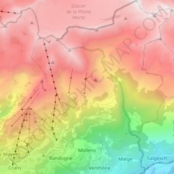
Name: Mollens (VS) topographic map, elevation, terrain.
Location: Mollens (VS), Crans-Montana, Sierre, Wallis, 3960, Switzerland (46.30380 7.49932 46.38897 7.58017)
Average elevation: 1,996 m
Minimum elevation: 543 m
Maximum elevation: 3,150 m
Make a donation
Other topographic maps
Click on a map to view its topography, its elevation and its terrain.
Les Briesses
Switzerland > Wallis > Sierre > Crans-Montana > Chermignon-d'en-Bas
Average elevation: 1,179 m
Make a donation