
Thank you for supporting this site ❤️
Make a donation
Make a donation
Dauner Maare topographic map
Click on the map to display elevation.
Thank you for supporting this site ❤️
Make a donation
Make a donation
About this map
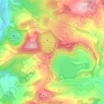
Name: Dauner Maare topographic map, elevation, terrain.
Average elevation: 468 m
Minimum elevation: 366 m
Maximum elevation: 557 m
Thank you for supporting this site ❤️
Make a donation
Make a donation
Other topographic maps
Click on a map to view its topography, its elevation and its terrain.
Vulkanfeld Westeifel
Deutschland > Rheinland-Pfalz > Landkreis Vulkaneifel > Schalkenmehren
Average elevation: 467 m
Gemündener Maar
Deutschland > Rheinland-Pfalz > Landkreis Vulkaneifel > Schalkenmehren
Average elevation: 447 m