
Thank you for supporting this site ❤️
Make a donation
Make a donation
Aracena topographic map
Click on the map to display elevation.
Thank you for supporting this site ❤️
Make a donation
Make a donation
About this map
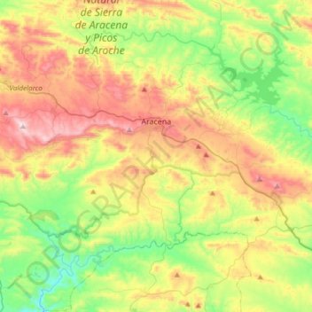
Name: Aracena topographic map, elevation, terrain.
Location: Aracena, Sierra de Huelva, Huelva, Andalusia, Spain (37.74991 -6.67481 37.98748 -6.44836)
Average elevation: 501 m
Minimum elevation: 201 m
Maximum elevation: 942 m
Thank you for supporting this site ❤️
Make a donation
Make a donation
Other topographic maps
Click on a map to view its topography, its elevation and its terrain.
Sierra de la Huerta del Abad
Spain > Andalusia > Sierra de Huelva > Aracena > Carboneras
Average elevation: 525 m