
Thank you for supporting this site ❤️
Make a donation
Make a donation
Muimenta topographic map
Click on the map to display elevation.
Thank you for supporting this site ❤️
Make a donation
Make a donation
About this map
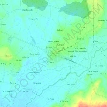
Name: Muimenta topographic map, elevation, terrain.
Location: Muimenta, Cospeito, Terra Chá, Lugo, Galicia, 27256, Spain (43.23309 -7.45137 43.27309 -7.41137)
Average elevation: 417 m
Minimum elevation: 405 m
Maximum elevation: 457 m
Thank you for supporting this site ❤️
Make a donation
Make a donation
Other topographic maps
Click on a map to view its topography, its elevation and its terrain.
Thank you for supporting this site ❤️
Make a donation
Make a donation
Castro de Rei
Castro de Rei is located in the comarca of the Terra Cha. This factor determines the most of their socioeconomic characteristics. Its average altitude is between 400 and 500 meters. In the east the terrain becomes more rugged due to its proximity to the eastern mountains. The elevation of the Montes dos…
Average elevation: 505 m