
Thank you for supporting this site ❤️
Make a donation
Make a donation
Bijar topographic map
Click on the map to display elevation.
Thank you for supporting this site ❤️
Make a donation
Make a donation
Bijar
With an elevation of 1,940 metres, Bijar has been called the Roof of Iran.
Thank you for supporting this site ❤️
Make a donation
Make a donation
About this map
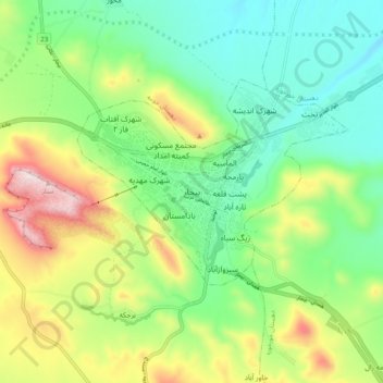
Name: Bijar topographic map, elevation, terrain.
Average elevation: 2,012 m
Minimum elevation: 1,809 m
Maximum elevation: 2,402 m
Thank you for supporting this site ❤️
Make a donation
Make a donation