
Make a donation
Le Riou topographic map
Click on the map to display elevation.
Make a donation
About this map
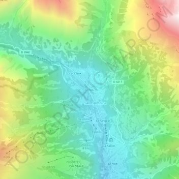
Name: Le Riou topographic map, elevation, terrain.
Average elevation: 1,693 m
Minimum elevation: 1,183 m
Maximum elevation: 2,746 m
Make a donation
Other topographic maps
Click on a map to view its topography, its elevation and its terrain.
Pelvoux
France > Provence-Alpes-Côte d'Azur > Hautes-Alpes > Vallouise-Pelvoux
Average elevation: 2,459 m
Lac de l'Eychauda
France > Provence-Alpes-Côte d'Azur > Hautes-Alpes > Vallouise-Pelvoux
Average elevation: 2,608 m
L'Onde
France > Provence-Alpes-Côte d'Azur > Hautes-Alpes > Vallouise-Pelvoux
Average elevation: 2,278 m
Vallouise
France > Provence-Alpes-Côte d'Azur > Hautes-Alpes > Vallouise-Pelvoux
Average elevation: 2,378 m
Make a donation
Vallouise
France > Provence-Alpes-Côte d'Azur > Hautes-Alpes > Vallouise-Pelvoux
Average elevation: 2,378 m
Glacier Noir
France > Provence-Alpes-Côte d'Azur > Hautes-Alpes > Vallouise-Pelvoux
Average elevation: 2,951 m
Refuge Cezanne
France > Provence-Alpes-Côte d'Azur > Hautes-Alpes > Vallouise-Pelvoux
Average elevation: 2,332 m
Refuge des Bans
France > Provence-Alpes-Côte d'Azur > Hautes-Alpes > Vallouise-Pelvoux
Average elevation: 2,506 m
Make a donation
Refuge de la Pilatte
France > Provence-Alpes-Côte d'Azur > Hautes-Alpes > Vallouise-Pelvoux
Average elevation: 2,800 m
Glacier Blanc
France > Provence-Alpes-Côte d'Azur > Hautes-Alpes > Vallouise-Pelvoux
Average elevation: 3,114 m