
Thank you for supporting this site ❤️
Make a donation
Make a donation
Tanggula Mountains topographic map
Click on the map to display elevation.
Thank you for supporting this site ❤️
Make a donation
Make a donation
Tanggula Mountains
The elevations of the main ridge average over 5,000 m (16,404 ft). The Yangtze River originates in this mountain range; Geladandong, 6,621 metres or 21,722 feet high, located in Tanggula Town, is the tallest peak in the range.
Thank you for supporting this site ❤️
Make a donation
Make a donation
About this map
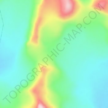
Name: Tanggula Mountains topographic map, elevation, terrain.
Average elevation: 5,912 m
Minimum elevation: 5,811 m
Maximum elevation: 6,149 m
Thank you for supporting this site ❤️
Make a donation
Make a donation