
Wathermal topographic map
Interactive map
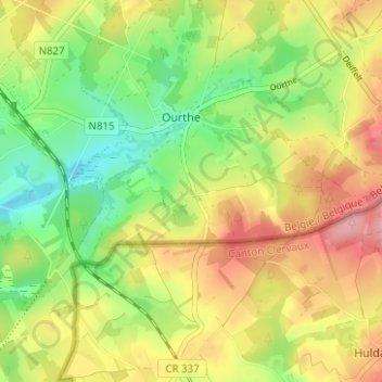
Click on the map to display elevation.
About this map
Name: Wathermal topographic map, elevation, terrain.
Average elevation: 489 m
Minimum elevation: 430 m
Maximum elevation: 556 m
Other topographic maps
Click on a map to view its topography, its elevation and its terrain.
Vaux
Belgique > Luxembourg > Bastogne > Gouvy
Vaux, Cherain, Gouvy, Bastogne, Luxembourg, Wallonie, 6674, Belgique
Average elevation: 436 m
Beho
Belgique > Luxembourg > Bastogne > Gouvy
Beho, Gouvy, Bastogne, Luxembourg, Wallonie, 6672, Belgique
Average elevation: 491 m
Limerlé
Belgique > Luxembourg > Bastogne > Gouvy
Limerlé, Gouvy, Bastogne, Luxembourg, Wallonie, Belgique
Average elevation: 471 m
Gouvy
Belgique > Luxembourg > Bastogne > Gouvy
Gouvy, Bastogne, Luxembourg, Wallonie, Belgique
Average elevation: 469 m