
Ryall topographic map
Click on the map to display elevation.
About this map
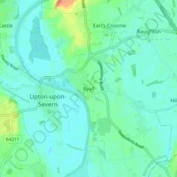
Name: Ryall topographic map, elevation, terrain.
Average elevation: 17 m
Minimum elevation: 7 m
Maximum elevation: 55 m
Other topographic maps
Click on a map to view its topography, its elevation and its terrain.
Broadheath
United Kingdom > England > Worcestershire > Malvern Hills > Lower Broadheath
Average elevation: 44 m
Knighton on Teme
United Kingdom > England > Worcestershire > Malvern Hills > Knighton on Teme
Average elevation: 82 m
West Malvern
United Kingdom > England > Worcestershire > Malvern Hills
West Malvern is a village and a civil parish on the west side of the north part of the Malvern Hills, on the western edge of Worcestershire, England. It has become effectively a suburb of Malvern and part of an urban area often called The Malverns, locally administered by Malvern Hills District Council and its…
Average elevation: 198 m