
Thank you for supporting this site ❤️
Make a donation
Make a donation
Rickarum topographic map
Click on the map to display elevation.
Thank you for supporting this site ❤️
Make a donation
Make a donation
About this map
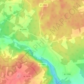
Name: Rickarum topographic map, elevation, terrain.
Location: Rickarum, Kristianstads kommun, Skåne län, Zweden (55.97551 13.79917 56.01551 13.83917)
Average elevation: 110 m
Minimum elevation: 68 m
Maximum elevation: 147 m
Thank you for supporting this site ❤️
Make a donation
Make a donation
Other topographic maps
Click on a map to view its topography, its elevation and its terrain.
Thank you for supporting this site ❤️
Make a donation
Make a donation
Thank you for supporting this site ❤️
Make a donation
Make a donation