
Make a donation
Brandbu topographic map
Click on the map to display elevation.
Make a donation
About this map
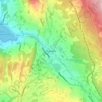
Name: Brandbu topographic map, elevation, terrain.
Location: Brandbu, Gran, Innlandet, 2760, Norway (60.40075 10.48700 60.44075 10.52700)
Average elevation: 243 m
Minimum elevation: 131 m
Maximum elevation: 425 m
Make a donation
Other topographic maps
Click on a map to view its topography, its elevation and its terrain.
Dovre
The Dovre area is in a valley at fairly high altitude and isolated from the sea by mountain ranges, giving some rain shadow effect for Dovre. Dovre, with the town Dombås, has a subarctic climate (Dfc) with sparse precipitation. The driest season is late winter and spring, and the wettest season is summer.…
Average elevation: 1,195 m
Make a donation
Make a donation
Make a donation
Hamar
Hamar has a humid continental climate (Dfb) with fairly dry and cold winters, and comfortably warm summers. The Hamar II weather station, at an elevation of 141 metres (463 ft), started recording in 1968. The all-time high 33 °C (91 °F) was recorded in July 2018, which was the warmest month on record with…
Average elevation: 445 m
Make a donation
Make a donation
Make a donation
Make a donation
Make a donation