
Thank you for supporting this site ❤️
Make a donation
Make a donation
Bashagard County topographic map
Click on the map to display elevation.
Thank you for supporting this site ❤️
Make a donation
Make a donation
About this map
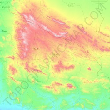
Name: Bashagard County topographic map, elevation, terrain.
Location: Bashagard County, Hormozgan Province, Iran (26.08731 57.36803 26.93421 59.00920)
Average elevation: 638 m
Minimum elevation: 1 m
Maximum elevation: 2,139 m
Thank you for supporting this site ❤️
Make a donation
Make a donation
Other topographic maps
Click on a map to view its topography, its elevation and its terrain.
Thank you for supporting this site ❤️
Make a donation
Make a donation
Thank you for supporting this site ❤️
Make a donation
Make a donation
Thank you for supporting this site ❤️
Make a donation
Make a donation
Thank you for supporting this site ❤️
Make a donation
Make a donation
چاه حسن کهوری
Iran > Hormozgan Province > Bandar-e-Abbas County > دهستان ایسین
Average elevation: 148 m
Thank you for supporting this site ❤️
Make a donation
Make a donation