
Jonggol topographic map
Click on the map to display elevation.
Jonggol
Jonggol town is located about 50 kilometres (31 mi) southeast of Jakarta. The average elevation in the district is 295 metres, maximum 732 m (1.890 m in Mounth Baud, Sukamakmur, Jonggol District), and minimum 150 metres above sea level.
About this map
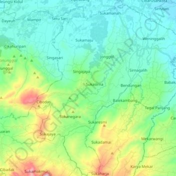
Name: Jonggol topographic map, elevation, terrain.
Location: Jonggol, Bogor, West Java, Java, 16830, Indonesia (-6.58699 106.97807 -6.42932 107.13122)
Average elevation: 237 m
Minimum elevation: 34 m
Maximum elevation: 870 m
Other topographic maps
Click on a map to view its topography, its elevation and its terrain.
Ciliwung
Mean rainfall reaches 3,125 mm, with a mean annual discharge of 16 m3/s as measured at Ciliwung Ratujaya observation station (231 km2). With such topographical, geological, and hydrological features, the Ciliwung River is often overflowing and inundating parts of Jakarta. The population along the Ciliwung…
Average elevation: 328 m
Megamendung
Much of the district lies at an elevation of 500-600 metres, which moderates the temperature, and causing contrast to the heat of Greater Jakarta and other adjacent low-lying lands. Though much of the built-up area is not necessarily on rugged terrain, uneven ground is the most common terrain as it stands…
Average elevation: 776 m
Ciliwung
Mean rainfall reaches 3,125 mm, with a mean annual discharge of 16 m3/s as measured at Ciliwung Ratujaya observation station (231 km2). With such topographical, geological, and hydrological features, the Ciliwung River is often overflowing and inundating parts of Jakarta. The population along the Ciliwung…
Average elevation: 229 m
Ciliwung
Mean rainfall reaches 3,125 mm, with a mean annual discharge of 16 m3/s as measured at Ciliwung Ratujaya observation station (231 km2). With such topographical, geological, and hydrological features, the Ciliwung River is often overflowing and inundating parts of Jakarta. The population along the Ciliwung…
Average elevation: 328 m