
Stotfold topographic map
Interactive map
Click on the map to display elevation.
About this map
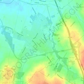
Name: Stotfold topographic map, elevation, terrain.
Location: Stotfold, Central Bedfordshire, England, United Kingdom (51.99794 -0.24543 52.03243 -0.20128)
Average elevation: 54 m
Minimum elevation: 37 m
Maximum elevation: 83 m
Other topographic maps
Click on a map to view its topography, its elevation and its terrain.
Heath and Reach
United Kingdom > England > Central Bedfordshire
Heath and Reach, Central Bedfordshire, England, United Kingdom
Average elevation: 120 m
Leighton Buzzard
United Kingdom > England > Central Bedfordshire
Leighton Buzzard, Central Bedfordshire, England, LU7 1EE, United Kingdom
Average elevation: 103 m
Linslade
United Kingdom > England > Central Bedfordshire
Linslade, Central Bedfordshire, England, LU7 2RG, United Kingdom
Average elevation: 104 m
Clifton
United Kingdom > England > Central Bedfordshire
Clifton, Central Bedfordshire, England, United Kingdom
Average elevation: 45 m
Lower Stondon
United Kingdom > England > Central Bedfordshire
Lower Stondon, Central Bedfordshire, England, SG16 6JT, United Kingdom
Average elevation: 57 m
Little Billington
United Kingdom > England > Central Bedfordshire > Great Billington > Little Billington
Little Billington, Great Billington, Central Bedfordshire, England, LU7 9GN, United Kingdom
Average elevation: 92 m
Gravenhurst
United Kingdom > England > Central Bedfordshire
Gravenhurst, Central Bedfordshire, England, United Kingdom
Average elevation: 59 m
Stanford
United Kingdom > England > Central Bedfordshire > Stanford
Stanford, Central Bedfordshire, England, SG18 9JF, United Kingdom
Average elevation: 42 m
Redlodge Plantation
United Kingdom > England > Central Bedfordshire > Woburn
Redlodge Plantation, Woburn, Central Bedfordshire, East of England, England, United Kingdom
Average elevation: 122 m
Meppershall
United Kingdom > England > Central Bedfordshire
Meppershall, Central Bedfordshire, England, United Kingdom
Average elevation: 58 m
Cranfield
United Kingdom > England > Central Bedfordshire > Cranfield
Cranfield, Central Bedfordshire, East of England, England, United Kingdom
Average elevation: 88 m
Dunstable
United Kingdom > England > Central Bedfordshire
Dunstable, Central Bedfordshire, England, United Kingdom
Average elevation: 158 m
Whipsnade
United Kingdom > England > Central Bedfordshire
Whipsnade, Central Bedfordshire, England, United Kingdom
Average elevation: 178 m
Tempsford
United Kingdom > England > Central Bedfordshire
Tempsford, Central Bedfordshire, England, United Kingdom
Average elevation: 22 m
Potton
United Kingdom > England > Central Bedfordshire
Potton, Central Bedfordshire, England, United Kingdom
Average elevation: 51 m