
Thank you for supporting this site ❤️
Make a donation
Make a donation
Matthias-Schmidt-Berg topographic map
Click on the map to display elevation.
Thank you for supporting this site ❤️
Make a donation
Make a donation
About this map
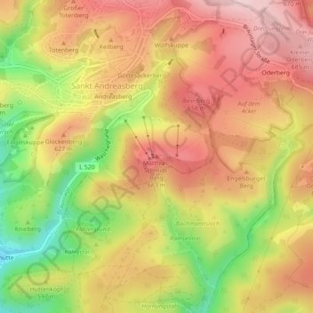
Name: Matthias-Schmidt-Berg topographic map, elevation, terrain.
Average elevation: 589 m
Minimum elevation: 435 m
Maximum elevation: 699 m
Thank you for supporting this site ❤️
Make a donation
Make a donation
Other topographic maps
Click on a map to view its topography, its elevation and its terrain.
Oderbrück
Duitsland > Nedersaksen > Landkreis Goslar > Braunlage > Sankt Andreasberg
Average elevation: 803 m