
Thank you for supporting this site ❤️
Make a donation
Make a donation
Carcross topographic map
Click on the map to display elevation.
Thank you for supporting this site ❤️
Make a donation
Make a donation
About this map
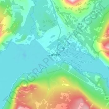
Name: Carcross topographic map, elevation, terrain.
Location: Carcross, Yukon, Y0B 1B0, Canada (60.12922 -134.74958 60.20922 -134.66958)
Average elevation: 782 m
Minimum elevation: 642 m
Maximum elevation: 1,305 m
Thank you for supporting this site ❤️
Make a donation
Make a donation
Other topographic maps
Click on a map to view its topography, its elevation and its terrain.
Kluane National Park and Reserve
The Reserve includes the highest mountain in Canada, Mount Logan (5,959 metres or 19,551 feet) of the Saint Elias Mountains. Mountains and glaciers dominate the park's landscape, covering 83% of its area. The rest of the land in the park is forest and tundra—east of the largest mountains and glaciers—where…
Average elevation: 1,536 m
Thank you for supporting this site ❤️
Make a donation
Make a donation