
Zion topographic map
Interactive map
Click on the map to display elevation.
About this map
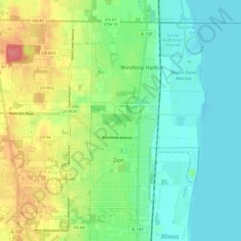
Name: Zion topographic map, elevation, terrain.
Average elevation: 198 m
Minimum elevation: 173 m
Maximum elevation: 247 m
Other topographic maps
Click on a map to view its topography, its elevation and its terrain.
Wauconda
Vereinigte Staaten von Amerika > Illinois > Lake County
Wauconda, Lake County, Illinois, 60084, Vereinigte Staaten von Amerika
Average elevation: 242 m
Wauconda
Vereinigte Staaten von Amerika > Illinois > Lake County > Wauconda > Wauconda
Wauconda, Lake County, Illinois, 60084, Vereinigte Staaten von Amerika
Average elevation: 243 m