
Thank you for supporting this site ❤️
Make a donation
Make a donation
Flattop Mountain topographic map
Click on the map to display elevation.
Thank you for supporting this site ❤️
Make a donation
Make a donation
About this map
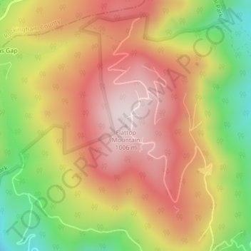
Name: Flattop Mountain topographic map, elevation, terrain.
Location: Flattop Mountain, Greene County, Virginia, United States (38.29369 -78.60507 38.29379 -78.60497)
Average elevation: 760 m
Minimum elevation: 439 m
Maximum elevation: 1,002 m
Thank you for supporting this site ❤️
Make a donation
Make a donation
Other topographic maps
Click on a map to view its topography, its elevation and its terrain.