
Thank you for supporting this site ❤️
Make a donation
Make a donation
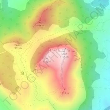
Stol topographic map
Click on the map to display elevation.
Thank you for supporting this site ❤️
Make a donation
Make a donation
Stol
Stol (Serbian Cyrillic: Стол) is a mountain in eastern Serbia, near the town of Bor. Its highest peak has an elevation of 1,156 meters above sea level. Like nearby Veliki Krš and Mali Krš, Stol has a number of pronounced karst formations. There is a mountain hut with around 35 beds, maintained by the mountaineering society Crni Vrh from Bor.
Thank you for supporting this site ❤️
Make a donation
Make a donation
About this map
Name: Stol topographic map, elevation, terrain.
Average elevation: 805 m
Minimum elevation: 491 m
Maximum elevation: 1,148 m
Thank you for supporting this site ❤️
Make a donation
Make a donation