
Thank you for supporting this site ❤️
Make a donation
Make a donation
Altham topographic map
Click on the map to display elevation.
Thank you for supporting this site ❤️
Make a donation
Make a donation
About this map
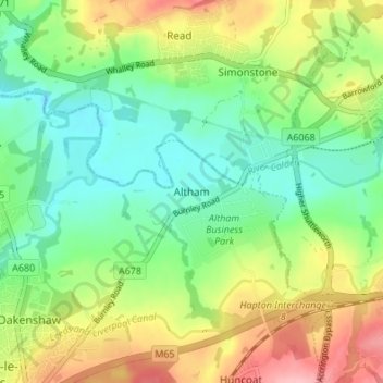
Name: Altham topographic map, elevation, terrain.
Location: Altham, Hyndburn, Lancashire, England, BB5 5UQ, United Kingdom (53.77244 -2.37303 53.81244 -2.33303)
Average elevation: 106 m
Minimum elevation: 57 m
Maximum elevation: 185 m
Thank you for supporting this site ❤️
Make a donation
Make a donation
Other topographic maps
Click on a map to view its topography, its elevation and its terrain.
Oswaldtwistle Moor
United Kingdom > England > Lancashire > Hyndburn > Green Haworth > Cocker Brook
Average elevation: 300 m