
Make a donation
Wickatunk topographic map
Click on the map to display elevation.
Make a donation
About this map
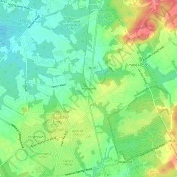
Name: Wickatunk topographic map, elevation, terrain.
Average elevation: 47 m
Minimum elevation: 17 m
Maximum elevation: 95 m
Make a donation
Other topographic maps
Click on a map to view its topography, its elevation and its terrain.
Morganville
United States > New Jersey > Monmouth County > Marlboro Township
According to the U.S. Census Bureau, Morganville has a total area of 5.42 square miles (14.04 km2), including 0.006 square miles (0.016 km2) of water (0.11%). Mount Pleasant, with an elevation of 364 feet (111 m), is in the southeast part of the community. Land in Morganville drains north via Gravelly Brook…
Average elevation: 37 m