
Make a donation
Santa Ana Pueblo topographic map
Click on the map to display elevation.
Make a donation
About this map
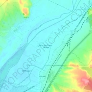
Name: Santa Ana Pueblo topographic map, elevation, terrain.
Average elevation: 1,558 m
Minimum elevation: 1,538 m
Maximum elevation: 1,638 m
Make a donation
Other topographic maps
Click on a map to view its topography, its elevation and its terrain.
Bandelier National Monument
United States > New Mexico > Sandoval County
The monument is 50 square miles (130 km2) of the Pajarito Plateau, on the slopes of the Jemez volcanic field in the Jemez Mountains. Over 70% of the monument is wilderness, with over one mile of elevation change, from about 5,000 feet (1,500 m) along the Rio Grande to over 10,000 feet (3,000 m) at the peak of…
Average elevation: 2,130 m
Make a donation
Kasha-Katuwe Tent Rocks National Monument
United States > New Mexico > Sandoval County
Average elevation: 1,852 m
Make a donation
San Felipe Pueblo
United States > New Mexico > Sandoval County > San Felipe Pueblo
Average elevation: 1,640 m