
Make a donation
La Ferrière topographic map
Click on the map to display elevation.
Make a donation
La Ferrière
Le point le plus bas se trouve à Biaufond, au bord du Doubs, à 609 mètres d’altitude. Le point le plus élevé se trouve sur la Montagne du Droit, à 1 150 mètres d’altitude.
Make a donation
About this map
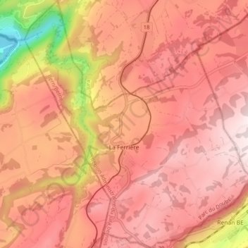
Name: La Ferrière topographic map, elevation, terrain.
Average elevation: 999 m
Minimum elevation: 608 m
Maximum elevation: 1,170 m
Make a donation
Other topographic maps
Click on a map to view its topography, its elevation and its terrain.
Moron
Suisse > Berne > Arrondissement administratif du Jura bernois > Valbirse
Average elevation: 1,101 m
Col du Mont Crosin
Suisse > Berne > Arrondissement administratif du Jura bernois > Courtelary
Average elevation: 1,140 m
Les Reussilles
Suisse > Berne > Arrondissement administratif du Jura bernois
Average elevation: 1,022 m
Les Savagnières-Dessous
Suisse > Berne > Arrondissement administratif du Jura bernois > Saint-Imier
Average elevation: 1,137 m
Make a donation
Mont Raimeux
Suisse > Berne > Arrondissement administratif du Jura bernois > Grandval
Average elevation: 1,048 m
La Cibourg
Suisse > Berne > Arrondissement administratif du Jura bernois > Renan (BE)
Average elevation: 1,031 m
Sous le Mont
Suisse > Berne > Arrondissement administratif du Jura bernois > Tavannes
Average elevation: 904 m
Les Ecorcheresses
Suisse > Berne > Arrondissement administratif du Jura bernois > Petit-Val > Souboz > Les Ecorcheresses
Average elevation: 1,019 m
Make a donation
Saint-Imier
Suisse > Berne > Arrondissement administratif du Jura bernois > Saint-Imier > Saint-Imier
Average elevation: 1,011 m