
Thank you for supporting this site ❤️
Make a donation
Make a donation
Courchapoix topographic map
Click on the map to display elevation.
Thank you for supporting this site ❤️
Make a donation
Make a donation
About this map
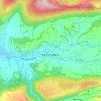
Name: Courchapoix topographic map, elevation, terrain.
Location: Courchapoix, District de Delémont, Jura, 2825, Suisse (47.32803 7.43806 47.37349 7.46508)
Average elevation: 607 m
Minimum elevation: 459 m
Maximum elevation: 945 m
Thank you for supporting this site ❤️
Make a donation
Make a donation
Other topographic maps
Click on a map to view its topography, its elevation and its terrain.
Dos le Chavelier
Suisse > Jura > District de Delémont > Delémont > Dos le Chavelier
Average elevation: 541 m
Thank you for supporting this site ❤️
Make a donation
Make a donation