
Thank you for supporting this site ❤️
Make a donation
Make a donation
Leyburn topographic map
Click on the map to display elevation.
Thank you for supporting this site ❤️
Make a donation
Make a donation
About this map
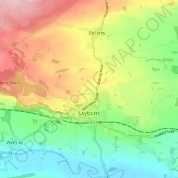
Name: Leyburn topographic map, elevation, terrain.
Location: Leyburn, North Yorkshire, England, United Kingdom (54.29398 -1.88116 54.33917 -1.80842)
Average elevation: 195 m
Minimum elevation: 100 m
Maximum elevation: 327 m
Thank you for supporting this site ❤️
Make a donation
Make a donation
Other topographic maps
Click on a map to view its topography, its elevation and its terrain.
Thank you for supporting this site ❤️
Make a donation
Make a donation
Thank you for supporting this site ❤️
Make a donation
Make a donation
Thank you for supporting this site ❤️
Make a donation
Make a donation
Thank you for supporting this site ❤️
Make a donation
Make a donation
Thank you for supporting this site ❤️
Make a donation
Make a donation
Thornydale Laithe
United Kingdom > England > North Yorkshire > Craven > Calton
Average elevation: 179 m
Thank you for supporting this site ❤️
Make a donation
Make a donation
Milby Cut
United Kingdom > England > North Yorkshire > Harrogate > Aldborough > Milby
Average elevation: 20 m