
سروبي ولسوالۍ topographic map
Interactive map
Click on the map to display elevation.
About this map
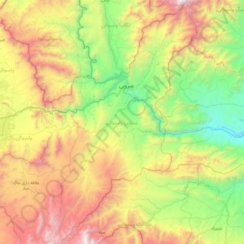
Name: سروبي ولسوالۍ topographic map, elevation, terrain.
Location: سروبي ولسوالۍ, Province de Kaboul, Afghanistan (34.20760 69.45149 34.85363 69.94387)
Average elevation: 1,857 m
Minimum elevation: 669 m
Maximum elevation: 4,017 m
Other topographic maps
Click on a map to view its topography, its elevation and its terrain.
Koh Chihil Dukhtaran
Afghanistan > Province de Kaboul > ولسوالی پغمان > شهرک اتفاق
Koh Chihil Dukhtaran, شهرک اتفاق, ولسوالی پغمان, Province de Kaboul, 1016, Afghanistan
Average elevation: 1,960 m
Kaboul
Afghanistan > Province de Kaboul > District de Kaboul
Kaboul, District de Kaboul, Province de Kaboul, 1001, Afghanistan
Average elevation: 1,945 m