
Nohfelden topographic map
Interactive map
Click on the map to display elevation.
About this map
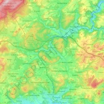
Name: Nohfelden topographic map, elevation, terrain.
Location: Nohfelden, Landkreis St. Wendel, Saarland, 66625, Deutschland (49.52205 6.99085 49.63943 7.21398)
Average elevation: 432 m
Minimum elevation: 292 m
Maximum elevation: 693 m
Other topographic maps
Click on a map to view its topography, its elevation and its terrain.
St. Wendel
Deutschland > Saarland > Landkreis St. Wendel
St. Wendel, Landkreis St. Wendel, Saarland, Deutschland
Average elevation: 365 m
Tholey
Deutschland > Saarland > Landkreis St. Wendel
Tholey, Landkreis St. Wendel, Saarland, 66636, Deutschland
Average elevation: 360 m