
Thank you for supporting this site ❤️
Make a donation
Make a donation
Jonesboro topographic map
Click on the map to display elevation.
Thank you for supporting this site ❤️
Make a donation
Make a donation
About this map
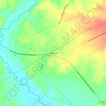
Name: Jonesboro topographic map, elevation, terrain.
Location: Jonesboro, Coryell County, Texas, United States (31.59604 -97.89700 31.63604 -97.85700)
Average elevation: 284 m
Minimum elevation: 258 m
Maximum elevation: 320 m
Thank you for supporting this site ❤️
Make a donation
Make a donation
Other topographic maps
Click on a map to view its topography, its elevation and its terrain.