
Thank you for supporting this site ❤️
Make a donation
Make a donation
Pleasant Hill topographic map
Click on the map to display elevation.
Thank you for supporting this site ❤️
Make a donation
Make a donation
About this map
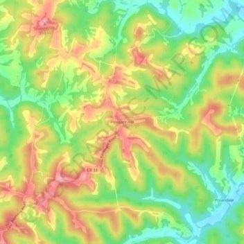
Name: Pleasant Hill topographic map, elevation, terrain.
Location: Pleasant Hill, Wood County, West Virginia, United States (39.16702 -81.61151 39.20702 -81.57151)
Average elevation: 245 m
Minimum elevation: 186 m
Maximum elevation: 307 m
Thank you for supporting this site ❤️
Make a donation
Make a donation
Other topographic maps
Click on a map to view its topography, its elevation and its terrain.