
Thank you for supporting this site ❤️
Make a donation
Make a donation
Jadovnik topographic map
Click on the map to display elevation.
Thank you for supporting this site ❤️
Make a donation
Make a donation
Jadovnik
Jadovnik (Serbian Cyrillic: Јадовник, pronounced [jâdɔːʋniːk]) is a mountain in southwestern Serbia, on the western edge of Pešter plateau, between towns of Prijepolje and Sjenica. Its highest peak Katunić has an elevation of 1,734 meters above sea level.
Thank you for supporting this site ❤️
Make a donation
Make a donation
About this map
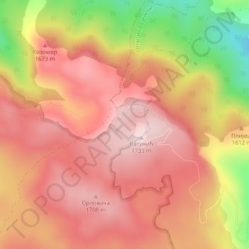
Name: Jadovnik topographic map, elevation, terrain.
Average elevation: 1,586 m
Minimum elevation: 1,324 m
Maximum elevation: 1,726 m
Thank you for supporting this site ❤️
Make a donation
Make a donation