
Thank you for supporting this site ❤️
Make a donation
Make a donation
Lunenburg topographic map
Click on the map to display elevation.
Thank you for supporting this site ❤️
Make a donation
Make a donation
About this map
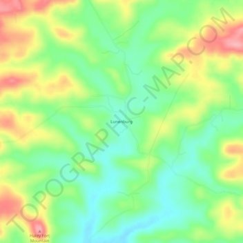
Name: Lunenburg topographic map, elevation, terrain.
Location: Lunenburg, Izard County, Arkansas, United States (35.98257 -91.92765 36.02257 -91.88765)
Average elevation: 160 m
Minimum elevation: 112 m
Maximum elevation: 228 m
Thank you for supporting this site ❤️
Make a donation
Make a donation
Other topographic maps
Click on a map to view its topography, its elevation and its terrain.