
Thank you for supporting this site ❤️
Make a donation
Make a donation
Staatswald Galm topographic map
Click on the map to display elevation.
Thank you for supporting this site ❤️
Make a donation
Make a donation
About this map
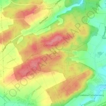
Name: Staatswald Galm topographic map, elevation, terrain.
Location: Staatswald Galm, District du Lac, Fribourg, Suisse (46.90252 7.16344 46.93077 7.19213)
Average elevation: 565 m
Minimum elevation: 515 m
Maximum elevation: 606 m
Thank you for supporting this site ❤️
Make a donation
Make a donation
Other topographic maps
Click on a map to view its topography, its elevation and its terrain.