
Thank you for supporting this site ❤️
Make a donation
Make a donation
Lac Bird topographic map
Click on the map to display elevation.
Thank you for supporting this site ❤️
Make a donation
Make a donation
About this map
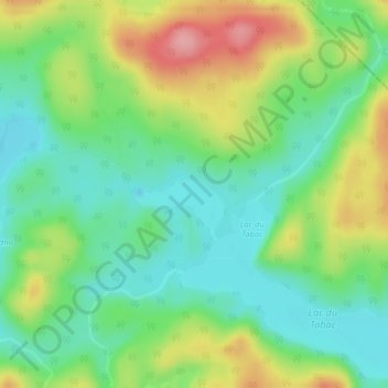
Name: Lac Bird topographic map, elevation, terrain.
Location: Lac Bird, Baie-Obaoca, Matawinie, Lanaudière, Québec, Canada (47.69187 -74.43750 47.69197 -74.43740)
Average elevation: 530 m
Minimum elevation: 484 m
Maximum elevation: 608 m
Thank you for supporting this site ❤️
Make a donation
Make a donation
Other topographic maps
Click on a map to view its topography, its elevation and its terrain.